

NOTIFICATIONS
26th Oct

 এটি 'অতি প্রবল ঘূর্ণিঝড়ে' পরিণত হতে পারে বলে মনে করছেন মৌসম ভবনের প্রধান মৃত্যুঞ্জয় মহাপাত্র।

Cyclone Arnab: বঙ্গোপসাগরে শক্তি বাড়ছে ঘূর্ণিঝড় অর্ণবের। পরিস্থিতির দিকে নজর রাখছে আবহাওয়া দফতর। এটি 'অতি প্রবল ঘূর্ণিঝড়ে' পরিণত হতে পারে বলে মনে করছেন মৌসম ভবনের প্রধান মৃত্যুঞ্জয় মহাপাত্র। 'সাইক্লোন ম্যান অফ ইন্ডিয়া' নামেও জনপ্রিয় তিনি। এর আগে বিভিন্ন সাইক্লোনের নিখুঁত পূর্বাভাস দিয়েছেন। ফলে স্বাভাবিকভাবেই তাঁর বিশ্লেষণের একটি আলাদা তাৎপর্য রয়েছে। সংবাদমাধ্যমকে মৃত্যুঞ্জয় মহাপাত্র জানালেন, আগামী ২৮ অক্টোবর সকালে অন্ধ্রপ্রদেশ উপকূলে ঘূর্ণিঝড় আছড়ে পড়তে পারে। সেই সময় ঝড়ের সর্বোচ্চ গতিবেগ ঘণ্টায় ১২৫ কিলোমিটার পর্যন্ত পৌঁছতে পারে।
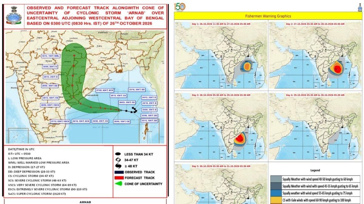
#WATCH | Delhi: Dr Mrutyunjay Mohapatra, DG IMD, says, "It has intensified into cyclonic storm 'Arnab' today morning. By noon today, it is located over the central part of the Bay of Bengal, about 650 kilometres away from Kakinada. As per our prediction, it is expected to move west-northwestwards and intensify into a severe cyclonic storm by today evening, and further into a very severe cyclonic storm by tomorrow. It will continue to move west-northwestwards and cross the Andhra Pradesh coast between Bapatla and Visakhapatnam, close to Yanam and Kakinada, during the forenoon of 28 October 2026. At the time of landfall, it will be a very severe cyclonic storm with a maximum sustained wind speed of 115 to 125 kilometres per hour, gusting to 140 kilometres per hour. At present, its wind speed is about 70 to 80 kilometres per hour, gusting to 90 kilometres per hour, and the sea condition is high. The sea condition will gradually become very high to phenomenal, meaning the wave height over the sea will be more than 14 metres tomorrow. Along the South Odisha coast, the wind speed will be around 60 to 80 kilometres per hour, gusting to 90 kilometres per hour. There will also be a storm surge of 1 to 1.5 metres above the astronomical tide, which is expected to inundate low-lying areas of coastal districts in Andhra Pradesh, especially North Andhra Pradesh, with the maximum storm surge expected over the East Godavari, Kakinada, and Yanam areas. Under its influence, rainfall will commence from the 27th, and the maximum rainfall will occur on the 28th over Andhra Pradesh and Odisha...Transport will be affected, especially the Indian Railways, national highways, and air transport on the 28th, starting from the evening of the 27th. Ports and shipping activity will also be affected. Consequently, fishermen have been advised not to venture into the sea, and a complete suspension of fishing operations has been recommended."
— ANI (@ANI) October 26, 2026
সোমবার দুপুরের আপডেট অনুযায়ী, ঘূর্ণিঝড় আপাতত মধ্য বঙ্গোপসাগরে অবস্থান করছে। অন্ধ্রপ্রদেশের কাকিনাড়া থেকে তার দূরত্ব প্রায় ৬৫০ কিলোমিটার। মৃত্যুঞ্জয়বাবুর পূর্বাভাস, সোমবার সন্ধ্যার মধ্যে এটি প্রবল ঘূর্ণিঝড়ে পরিণত হতে পারে। মঙ্গলবার আরও শক্তি বাড়িয়ে অতি প্রবল ঘূর্ণিঝড়ে পরিণত হওয়ার আশঙ্কা রয়েছে।
অর্ণবের ল্যান্ডফল, ছবিতে বুঝুন:
IMD-র পূর্বাভাস, ২৮ অক্টোবর সকালে ঘূর্ণিঝড় বাপটলা ও বিশাখাপত্তনমের মাঝামাঝি অন্ধ্রপ্রদেশ উপকূল অতিক্রম করতে পারে। ইয়ানাম ও কাকিনাড়ার কাছাকাছি আছড়ে পড়ার সম্ভাবনা। উপকূলে আছড়ে পড়ার সময় ঘণ্টায় ১১৫-১২৫ কিলোমিটার বেগে হাওয়া বইতে পারে। দমকা হাওয়ার বেগ ঘণ্টায় ১৪০ কিলোমিটার পর্যন্ত পৌঁছতে পারে।
উত্তাল সমুদ্র, জলোচ্ছ্বাসের আশঙ্কা
মৃত্যুঞ্জয় মহাপাত্র জানিয়েছেন, ঘূর্ণিঝড়ের প্রভাবে সমুদ্র ক্রমশ উত্তাল হয়ে উঠবে। ঢেউয়ের উচ্চতা ১৪ মিটারেরও বেশি হতে পারে। অন্ধ্রপ্রদেশের উপকূলবর্তী নিচু এলাকায় ১ থেকে দেড় মিটার পর্যন্ত জলোচ্ছ্বাসের আশঙ্কা রয়েছে। বিশেষ করে পূর্ব গোদাবরী, কাকিনাড়া ও ইয়ানাম এলাকায় প্রভাব বেশি পড়তে পারে। দক্ষিণ ওড়িশার উপকূলেও ঘণ্টায় ৬০-৮০ কিলোমিটার বেগে হাওয়া বইতে পারে।
২৭ অক্টোবর থেকে অন্ধ্রপ্রদেশ ও ওড়িশায় বৃষ্টি শুরু হতে পারে। ২৮ অক্টোবর বৃষ্টি বাড়ার সম্ভাবনা রয়েছে।